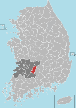
Jangsu County
Appearance
This article needs additional citations for verification. (August 2018) |
Jangsu
장수군 | |
|---|---|
| Korean transcription(s) | |
| • Hangul | 장수군 |
| • Hanja | 長水郡 |
| • Revised Romanization | Jangsu-gun |
| • McCune-Reischauer | Changsu-gun |
 Location in South Korea | |
| Country | |
| Region | Honam |
| Administrative divisions | 1 eup, 6 myeon |
| Area | |
• Total | 533.64 km2 (206.04 sq mi) |
| Population (September 2024[1]) | |
• Total | 24,277 |
| • Density | 41/km2 (110/sq mi) |
| • Dialect | Jeolla |
Jangsu County (Korean: 장수군; RR: Jangsu-gun) is a county in Jeonbuk State, South Korea. It is well known for Jangsu-Galbi.
Climate
[edit]| Climate data for Jangsu (1991–2020 normals, extremes 1988–present) | |||||||||||||
|---|---|---|---|---|---|---|---|---|---|---|---|---|---|
| Month | Jan | Feb | Mar | Apr | May | Jun | Jul | Aug | Sep | Oct | Nov | Dec | Year |
| Record high °C (°F) | 16.1 (61.0) |
19.7 (67.5) |
23.6 (74.5) |
28.9 (84.0) |
32.4 (90.3) |
32.8 (91.0) |
36.2 (97.2) |
36.5 (97.7) |
32.0 (89.6) |
29.5 (85.1) |
24.6 (76.3) |
17.0 (62.6) |
36.5 (97.7) |
| Mean daily maximum °C (°F) | 3.0 (37.4) |
5.8 (42.4) |
11.2 (52.2) |
17.8 (64.0) |
22.7 (72.9) |
25.9 (78.6) |
27.9 (82.2) |
28.6 (83.5) |
24.8 (76.6) |
19.6 (67.3) |
12.5 (54.5) |
5.3 (41.5) |
17.1 (62.8) |
| Daily mean °C (°F) | −3.0 (26.6) |
−0.8 (30.6) |
4.3 (39.7) |
10.5 (50.9) |
16.0 (60.8) |
20.1 (68.2) |
23.3 (73.9) |
23.4 (74.1) |
18.3 (64.9) |
11.6 (52.9) |
5.4 (41.7) |
−0.8 (30.6) |
10.7 (51.3) |
| Mean daily minimum °C (°F) | −8.6 (16.5) |
−6.6 (20.1) |
−2.0 (28.4) |
3.2 (37.8) |
9.2 (48.6) |
15.0 (59.0) |
19.5 (67.1) |
19.4 (66.9) |
13.2 (55.8) |
5.3 (41.5) |
−0.6 (30.9) |
−6.2 (20.8) |
5.1 (41.2) |
| Record low °C (°F) | −25.7 (−14.3) |
−25.8 (−14.4) |
−13.3 (8.1) |
−6.6 (20.1) |
−0.7 (30.7) |
4.5 (40.1) |
9.1 (48.4) |
10.6 (51.1) |
2.1 (35.8) |
−5.4 (22.3) |
−12.0 (10.4) |
−23.2 (−9.8) |
−25.8 (−14.4) |
| Average precipitation mm (inches) | 31.9 (1.26) |
45.5 (1.79) |
64.5 (2.54) |
96.6 (3.80) |
100.5 (3.96) |
164.9 (6.49) |
339.7 (13.37) |
336.5 (13.25) |
153.8 (6.06) |
63.6 (2.50) |
52.1 (2.05) |
36.4 (1.43) |
1,486 (58.50) |
| Average precipitation days (≥ 0.1 mm) | 8.6 | 7.4 | 9.1 | 9.1 | 9.0 | 10.9 | 16.4 | 15.2 | 9.3 | 6.7 | 8.1 | 9.3 | 119.1 |
| Average snowy days | 10.8 | 8.7 | 4.0 | 0.8 | 0.0 | 0.0 | 0.0 | 0.0 | 0.0 | 0.4 | 2.7 | 7.6 | 35.2 |
| Average relative humidity (%) | 72.2 | 69.2 | 66.7 | 64.3 | 67.7 | 75.3 | 81.3 | 81.4 | 80.4 | 77.0 | 75.2 | 74.0 | 73.7 |
| Mean monthly sunshine hours | 155.4 | 169.6 | 201.2 | 213.5 | 229.1 | 177.5 | 139.5 | 153.2 | 157.0 | 179.5 | 152.2 | 143.8 | 2,071.5 |
| Percent possible sunshine | 49.0 | 55.7 | 52.6 | 55.9 | 51.1 | 41.3 | 32.9 | 37.1 | 43.9 | 53.6 | 51.1 | 47.7 | 47.0 |
| Source: Korea Meteorological Administration (snow and percent sunshine 1981–2010)[2][3][4] | |||||||||||||
Twin towns – sister cities
[edit]Jangsu is twinned with:
 Anyang, South Korea (1996)
 Hapcheon, South Korea (1999)
 Jinhae-gu, South Korea (1999)
References
[edit]- ^ "Population statistics". Korea Ministry of the Interior and Safety. 2024.
- ^ "Climatological Normals of Korea (1991 ~ 2020)" (PDF) (in Korean). Korea Meteorological Administration. Archived from the original (PDF) on 29 January 2022. Retrieved 4 April 2022.
- ^ 순위값 - 구역별조회 (in Korean). Korea Meteorological Administration. Retrieved 4 April 2022.
- ^ "Climatological Normals of Korea" (PDF). Korea Meteorological Administration. 2011. Archived from the original (PDF) on 7 December 2016. Retrieved 8 December 2016.
Wikimedia Commons has media related to Jangsu.


